Archive for the 'Mysterious History' Category

Heliopolis. AKA Baalbek – The city with the 1,500 ton blocks

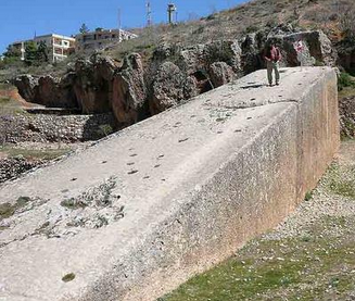
The most monumental of the ancient sites: Baalbek. And by monumental we mean this place has the largest building blocks that have ever existed in the world.


Screen Shot 2015-12-30 at 9.06.43 PM


From Ancient Origins,


The Monumental Baalbek – The largest building blocks on Earth


“In Lebanon, at an altitude of approximately 1,170 meters in Beqaa valley stands the famous Baalbek or known in Roman times as Heliopolis. Baalbek is an ancient site that has been used since the Bronze Age with a history of at least 9,000 years, according to evidence found during the German archaeological expedition in 1898.


Baalbek was an ancient Phoenician city that was named by the name of the sky God Baal. The name ‘Baal’ in the Phoenician language meant ‘lord’ or ‘god’. Legends abound around Baalbek with some of them mentioning that Baalbek was the place where Baal first arrived on Earth and thus ancient alien theorists suggest that the initial building was probably built as a platform to be used for sky God Baal to ‘land’ and ‘take off’.


Part of this suggestion is because Heliopolis was built on a massive platform that probably was built in pre-roman times for the initial temple or city of Baal – Baalbek. If you look at the picture it becomes obvious that different civilizations have built different parts of what is now known as Heliopolis. However beyond theories, the actual purpose of this structure as well as who has built it are completely unknown. Massive stone blocks have been used with the largest of the stones to be approximately 1,500 tons and a size of 68x14x14 feet. Those are the largest building blocks that have ever existed in the whole world…”


Read more here.

Share
800-Year-Old Seeds Grow Into A History-Altering Plant

You never know what you may find…


From Little Things dot com,


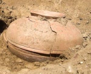
“This pot was unearthed on the Menominee Reservation in Wisconsin, where it had laid buried for the past 800 years.


Screen Shot 2015-12-29 at 2.09.29 PM


Inside, archaeologists found a stash of seeds. The seeds were probably buried in the pot as a method of storing food supplies. They were determined to be an old, now-extinct species of squash.


Now, seven years after making this stunning discovery, students in Winnipeg decided to plant the 800-year-old seeds — and, to everyone’s amazement, something grew…”


For the rest click here.


Share

What Do Butterflies and Ancient Maps Have In Common?

The Mapmaker’s Mystery…Undoubtedly this is one of the most interesting reads we’ve encountered in a long while.


Enjoy.


Screen Shot 2015-12-26 at 9.16.18 PM


From Discover,


The Mystery of Extraordinarily Accurate Medieval Maps
Beautifully detailed portolan charts present historians with a puzzle: How were they made? A mathematical analysis offers some clues.


By Julie Rehmeyer


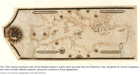
“One of the most remarkable and mysterious technical advances in the history of the world is written on the hide of a 13th-century calf. Inked into the vellum is a chart of the Mediterranean so accurate that ships today could navigate with it. Most earlier maps that included the region were not intended for navigation and were so imprecise that they are virtually unrecognizable to the modern eye.


With this map, it’s as if some medieval mapmaker flew to the heavens and sketched what he saw — though in reality, he could never have traveled higher than a church tower.


The person who made this document — the first so-called portolan chart, from the Italian word portolano, meaning “a collection of sailing directions” — spawned a new era of mapmaking and oceanic exploration. For the first time, Europeans could accurately visualize their continent in a way that enabled them to improvise new navigational routes instead of simply going from point to point.


That first portolan mapmaker also created an enormous puzzle for historians to come, because he left behind few hints of his method: no rough drafts, no sketches, no descriptions of his work. “Even with all the information he had — every sailor’s notebook, every description in every journal — I wouldn’t know how to make the map he made,” says John Hessler, a specialist in modern cartography at the Library of Congress.


But Hessler has approached the question using a tool that is foreign to most historians: mathematics. By systematically analyzing the discrepancies between the portolan charts and modern ones, Hessler has begun to trace the mapmaker’s tracks within the maps themselves…”


For the complete piece, click here.

Share

« Previous PageNext Page »